World Wind just so much hot air
Nasa's World Wind is a fat-client application that allows you to view the earth, moon, Mars, and Titan using satellite information to render "terrain in visually rich 3D, just as if you were really there." I downloaded the latest from the World Wind website (1.3.3.1) and installed it.
I installed the application while running on Windows XP SP2. It in turn installed 'managed' DirectX 9, which was basically DirectX 9c. After the installation was complete I had two icons on my desktop. One was for World Wind 1.3, and the other was for World Wind Moon 1.3. Which leads to a problem with the application (at least for me): it's written in C# and the version supplied by Nasa will only run on Windows. There is, however, activity afoot to port it to Mono on Linux.
I opened up both applications, first the moon, and then the earth. When both initially open they present a beautiful 3D view of the moon and the earth. And the interface is easy enough to learn so that I was both panning and zooming within five minutes of starting the applications. But I quickly learned that World Wind has poor resolution at high zoom levels and consumes 100% of the CPU at those high zoom levels.
Using the earth viewer as my prime example, I attempted to zoom into two areas on the earth that I'm somewhat familiar with: Orlando, Florida where I live, and New Orleans where an aunt and uncle of mine lived for nearly 20 years. In both cases World Wind could not resolve anything of significant detail at either location. Instead, I had to use Google Map to resolve details which World Wind could not.
First, we look at Orlando International Airport with World Wind.

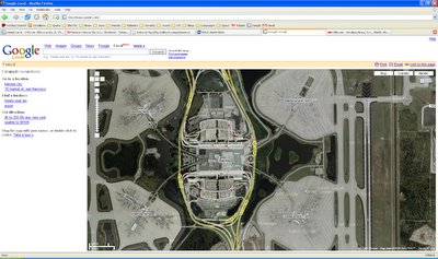
Then we look at Orlando International Airport with Google Map.

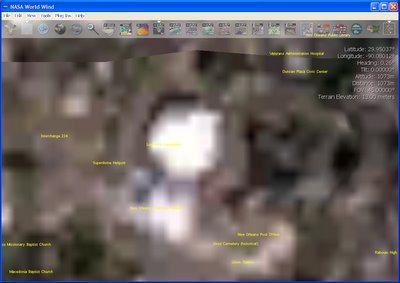
Next, we look at New Orleans and the Louisiana Superdome with World Wind.

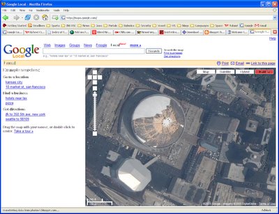
Then we compare that with Google Maps, this time looking at the images taken after Katrina.

As you can see from my screen shots the World Wind close-up resolution is horrible. I might concede that it's due to operator error, but even if I could correct the resolution, the system impact after zooming in close makes using World Wind pointless. When zoomed in to the levels shown in the screen shots, World Wind 1.3.3.1 was consuming 100% of the CPU. Google Maps with Firefox, by comparison, only spiked briefly to around 70% as map tiles were being downloaded and displayed on the map. Otherwise the Google Map/Firefox combination had no impact on the system at all.
Nasa's World Wind is, from my perspective, bloated, poorly designed and written. For maps and satellite imagery we're far better served by Google Maps.
I installed the application while running on Windows XP SP2. It in turn installed 'managed' DirectX 9, which was basically DirectX 9c. After the installation was complete I had two icons on my desktop. One was for World Wind 1.3, and the other was for World Wind Moon 1.3. Which leads to a problem with the application (at least for me): it's written in C# and the version supplied by Nasa will only run on Windows. There is, however, activity afoot to port it to Mono on Linux.
I opened up both applications, first the moon, and then the earth. When both initially open they present a beautiful 3D view of the moon and the earth. And the interface is easy enough to learn so that I was both panning and zooming within five minutes of starting the applications. But I quickly learned that World Wind has poor resolution at high zoom levels and consumes 100% of the CPU at those high zoom levels.
Using the earth viewer as my prime example, I attempted to zoom into two areas on the earth that I'm somewhat familiar with: Orlando, Florida where I live, and New Orleans where an aunt and uncle of mine lived for nearly 20 years. In both cases World Wind could not resolve anything of significant detail at either location. Instead, I had to use Google Map to resolve details which World Wind could not.
First, we look at Orlando International Airport with World Wind.

Then we look at Orlando International Airport with Google Map.

Next, we look at New Orleans and the Louisiana Superdome with World Wind.

Then we compare that with Google Maps, this time looking at the images taken after Katrina.

As you can see from my screen shots the World Wind close-up resolution is horrible. I might concede that it's due to operator error, but even if I could correct the resolution, the system impact after zooming in close makes using World Wind pointless. When zoomed in to the levels shown in the screen shots, World Wind 1.3.3.1 was consuming 100% of the CPU. Google Maps with Firefox, by comparison, only spiked briefly to around 70% as map tiles were being downloaded and displayed on the map. Otherwise the Google Map/Firefox combination had no impact on the system at all.
Nasa's World Wind is, from my perspective, bloated, poorly designed and written. For maps and satellite imagery we're far better served by Google Maps.

Comments
Post a Comment
All comments are checked. Comment SPAM will be blocked and deleted.